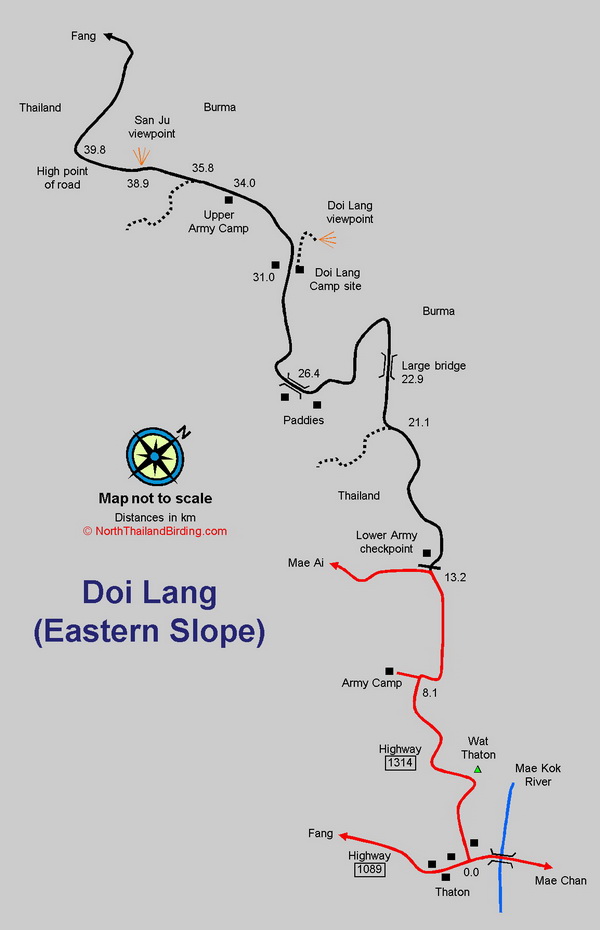
Overview
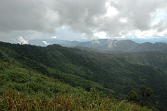
Doi Lang, forming part of the Doi Pha Hom Pok massif, lies only seven kilometres north of that peak. Although falling within the Doi Pha Hom Pok National Park it appears to receive little to no protection - although that doesn't stop the Department of National Parks charging the usual entry fee when they see fit. At around 2,100 metres altitude, Doi Lang is slightly lower than Doi Pha Hom Pok - the second highest peak in Thailand at 2,290 metres - but shares largely the same avifauna. Consequently, access to Doi Lang allows the chance to search for a number of species restricted to this remote northwestern corner of Thailand. Information on this page verified/accurate as of 17 Dec 2024.
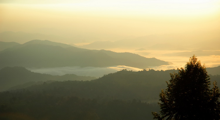
Sunrise from Doi Lang camp site
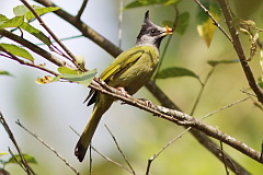
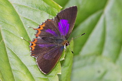
As much of this area lies directly on the Thailand-Burma border there is a heavy military presence in the form of checkpoints and camps, and access permission varies from time to time. Good evergreen forest is now largely restricted to the higher elevations of the eastern slope, where specialities such as Himalayan Cutia, Red-tailed Laughingthrush, Long-tailed Sibia, Necklaced Woodpecker, Whiskered Yuhina and Black-throated Bushtit occur. The western side is drier and contains more open pine-oak forest, though much has been cleared. This holds the elusive Giant Nuthatch, Mrs. Hume's Pheasant and Spot-breasted Parrotbill. Forest cover below 1,000 metres has mostly gone, but patches of scrub and various bamboo forest above this altitude, en route up the mountain, are worthy of investigation. A number of interesting Himalayan butterflies can likewise to be found, including several sapphire species.
Access
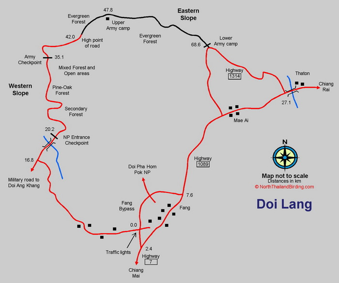
In the past, Doi Lang could be accessed from both the western and eastern slopes, from Fang or Thaton respectively. However, since about December 2022, access from the eastern side has been stopped. Plus the ongoing civil war in Burma can sometimes result in completely forbidden access. Driving from Fang is far easier, with a paved road as far as an army checkpoint allowing a standard saloon car to access. Road conditions from the Thaton side require a high clearance vehicle and 4x4 in the wet season. The military will not permit a saloon vehicle or minibus to pass up this slope. Formerly it was possible to complete a loop from either Thaton or Fang of about 110 kilometres, but checkpoint restrictions now mean a circuit cannot be completed. Being right on the Burma border it has only in the last few years that birders and tourists have been allowed up this road, and the situation could well be reversed if any border troubles flare up. It is important to carry identification which may be required at any of the checkpoints.
Western side. The western slope is accessed from Fang, about 150 kilometres north of Chiang Mai. From Chiang Mai the driving time is a little over three hours. When approaching Fang from Chiang Mai, take the Fang bypass just before town, signposted to Mae Ai, to the only set of traffic lights on the bypass. Zero the trip meter at the traffic lights and turn left, signposted towards Fang Hot Springs. Continue along this road for 16.8 kilometres then turn right. At 20.2 kilometres, just after the river, a national park checkpoint is reached, although this is often not functioning. Having paid the entrance fee if necessary, continue through a short stretch of orange orchards to the start of the forest. This road leads straight up the western slope, around the rear of Doi Pha Hom Pok. The army checkpoint reached at 35.1 kilometres is currently the limit of access.
Eastern side. The eastern slope is accessed from Thaton on the Mae Kok River, about 180 kilometres north of Chiang Mai. From Chiang Mai, head north on Highway 107 via Chiang Dao to Fang. Highway 107 ends at Fang, with Highway 1089 continuing north to Mae Ai, Thaton and beyond. From Fang it's 27.5 kilometres to Thaton. Starting from the large bridge over the Mae Kok River in Thaton, return 500 metres toward Chiang Mai and take the right turning, Highway 1314, up the hill. This road is signposted 1314 but no town or village is indicated. Zero the trip meter at this point. The road winds steeply uphill, and after 8.2 kilometres does a dog leg with an army camp on the left. Continue to 13.3 kilometres, at which point the main road swings left, with a narrow road on the right marked by a military check point and the lower army camp. If coming from Fang, it's also possible to turn off on Highway 1314 just before Mae Ai. Note that this checkpoint is only open from 08:00 - 17:00, with no access in or out, outside these hours. Passports are mandatory for visiting foreigners. Which other requirements are necessary to enter will depend on which people are manning the checkpoint. In November 2021 the Department of National Parks constructed a Ranger Station just before the checkpoint, and it might be necessary to register and pay there before being allowed entry. If not camping on the mountain it is mandatory to return to this checkpoint before 17:00. Above the checkpoint the road was originally sealed. However, years of heavy rain and little maintenance have resulted in this road requiring a vehicle with good clearance due to wash-outs, large ruts and pot-holes. In the wet season a 4x4 is necessary. Access permission beyond the upper army camp changes frequently and is not reliable. After the upper army camp at 34.0 kilometres the road is infrequently used and rather narrow with much vegetation, branches and bushes poking out along the road edge, especially in wet season. These often result in sizeable scratches along vehicles not driven with care. A machete is useful as branch falls occur. Keep an eye open for locals on motor cycles coming down at speed, as they are frequently on the wrong side of this narrow steep road, with the engine cut and poor brakes.
Accommodation and Facilities
On Doi Lang itself, once away from Thaton or Fang, there are virtually no facilities, and certainly it's necessary to take all food and water for the duration of the visit. In early 2012 an official camp site appeared on the eastern slope, where there is now a toilet block and some local huts which may offer limited shelter. Camping was also possible at the upper army camp, where there are basic toilet facilities, and the few army personnel based here seemed to enjoy visitors, and might even be persuaded to cook if provided with food brought up from below. Camping, either here or at the campsite, requires bringing all equipment. Due to the lack of facilities, most birders simply make long day trips from Fang or Thaton - either of which make an excellent base with good accommodation and restaurants. It's also a great deal warmer at 450 metres altitude than 1,700 metres plus on Doi Lang that in the cool season can be bitter at night and extremely soggy in the wet season. Note however, that in November 2018 a power line was run up the mountain to the campsite area, so it would seem future development in the area is possible if the security situation improves.
Fang has a number of resorts in and around town, although none with a restaurant, for which a trip to town is required. Thaton, being somewhat more of a tourist attraction - mainly as a stopover en route north - has a good number of resorts and guest houses to suit every budget. Other than at the resorts, a few restaurants can be found along the main street, open into the early evening. A few convenience stores, can also be found here, but the choice of snacks can be a little unexciting, so it's a good idea to bring any favourites from a larger town en route such as Chiang Mai or Fang. This situation has improved recently with the opening of a new 7-11 on the main street, which is open 24 hours.
|
BirdingA minimum of two full days on the mountain are required to do justice to the birds to be found, as many are scarce and elusive. One unfortunate thing about Doi Lang is that good birding tracks and trails away from the main road are almost nonexistent and many areas are mined. The best approach is simply to drive up and down the mountain stopping at any place that looks promising and walk the road. This plan can often be modified by the weather. On one hand, cool season early mornings at the summit can be birdless until the sun warms the trees, but during the rains higher elevations can become wet by mid morning so are best done early. Fog and wind frequently occur at the highest levels. Often, late afternoon is also rather birdless, so better lower down. Most birders concentrate on the upper sections of the road, as this is where the main specialities occur, but a number of stops lower down will also be interesting and add a number of additional species. Various sections along the road offer differing habitats and birds. |
Western slope: National Park Checkpoint to Army Checkpoint (Km 20.2 - Km 35.1)
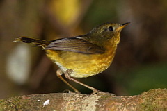
Once through the National Park checkpoint at 20.2 kilometres the immediate habitat is a kilometre of orange orchards for which Fang is famous. The road then enters the park proper with scrub, secondary growth and bamboo taking over at about 800 metres altitude. As all the speciality species are higher on the mountain few birders stop in this area, but it does holds mid elevation species not found higher, such as Little Cuckoo-Dove, Asian Fairy-bluebird and Ruby-cheeked Sunbird. Several kilometres later, having been through a number of hairpin bends the habitat suddenly changes to open pine-oak forest along a couple of ridges with good views of Doi Pha Hom Pok to the east. This area is the preferred habitat of Mrs. Hume's Pheasant and Mountain Bamboo Partridge, which are seen regularly. Hodgson's Frogmouth occurs also, though only vocal later in the dry season from about March onward. From here to the army checkpoint at 35.1 the habitat is a mixture of open dense grassland with stands of scattered oak and pine. The undergrowth supports White-bellied Redstart, Red-eyed Scimitar Babbler, White-browed Laughingthrush, Aberrant Bush Warbler and Grey-crowned Warbler. Larger pines should be checked for Giant Nuthatch, and the oaks for Sapphire Flycatcher, Himalayan Cutia and Rufous-backed Sibia among others. Odd rarities have turned up, such as Scarlet Finch. In recent years, photographers have taken to establishing a number of feeding stations, that vary greatly from year to year, offering the opportunity to see skulking species as they become habituated to being fed - the usual suspects including White-tailed Robin, White-gorgeted Flycatcher, Rufous-gorgeted Flycatcher, Slaty-blue Flycatcher, Silver-eared Laughingthrush and Rufous-bellied Niltava.
Western slope: Army Checkpoint to summit (Km 35.1 - Km 42.0)
Due to the immediate proximity of the Burma border, this army checkpoint can not be guarenteed to be open, and indeed during the wet season especially is regualrly closed by the military. The forest edge and open grassland around, and for a kilometre or so after, can be good for buntings, with Little Bunting, Crested Bunting and Chestnut Bunting in winter. Crested Finchbill and Brown-breasted Bulbul occur seasonally and Mountain Bamboo Partridge is often at field edges. The road here touches the Burma border, with the first of the Tai Yai (Shan State Army) camps, that have been seen dotting the hill tops, directly adjacent to the road. The remaining several kilometres up to the summit are predominantly open grassland with fragmented patches of forest. Any seeding plants can attract Black-headed Greenfinch in winter, and Russet Bush Warbler breeds, although only likely to be recorded by voice in the late dry season. Judging by the extent of the grassland here it would seem likely that other rarer bush warblers should be present such as Brown Bush Warbler and Pale-footed Bush Warbler. On approach to the summit the habitat starts to reflect the evergreen forest on the eastern slope of the mountain.
Eastern slope: Thaton to Lower Army Check point (Km 0.0 - Km 13.2)
The main paved Highway 1314 offers little of interest as most habitat has been cleared through agriculture. The road passes through a couple of hill tribe villages. However a few view points en route can be worth a scan for soaring raptors if passing at the appropriate time of day. Common, open-country species along here include Greater Coucal, Sooty-headed Bulbul, Ashy-throated Woodswallow, Eastern Red-rumped Swallow and Barn Swallow, with the occasional Blue Rock Thrush on rocky outcrops. Large areas of bamboo are also found which harbour some of the more skulking species such as Puff-throated Babbler.
Eastern slope: Lower Army Check point to Rice Paddies (Km 13.2 - Km 26.4)
This section is characterised by open secondary growth, scrub and a few remnant forest patches. Just after the check point, at Kilometres 13.5, 14.1 and 15.9 are minor viewpoints where it's possible to scan some remnant forested slopes; though the road is steep and narrow so parking can be an issue. Species possible include Shikra, Oriental Honey Buzzard, Wedge-tailed Green Pigeon, Blue-bearded Bee-eater, Puff-throated Babbler, and Rufous-fronted Babbler. Mountain Scops Owl and Large-tailed Nightjar. The stretch to about 20.0 kilometres is also the most likely area to encounter Mountain Bamboo Partridge which often feeds along the road edges early morning. At various points, tracks lead off the road mainly to plantations and agriculture. The rather open understorey of the taller trees along these tracks is often good for flycatchers and warblers such as Little Pied Flycatcher, Slaty-backed Flycatcher, Yellow-browed Warbler, Greenish Warbler, Davison's Leaf Warbler and the occasional Claudia's Leaf Warbler. Of the night birds, Himalayan Wood Owl occurs in the valleys either side of the ridge along which most of this road runs. At 21.1 kilometres a longer track runs for at least a kilometre through open, cut-over forest after which it descends strongly.
At Km 22.9 is a large bridge that makes an great breakfast stop with its excellent views across a wide gully, emergent trees and forest edge, that attract a fair collection of species in the early morning sun. Mountain Imperial Pigeon is frequently seen, as are Maroon Oriole, Great Barbet, White-rumped Munia, Hill Blue Flycatcher, Orange-bellied Leafbird, Streaked Spiderhunter, Black Bulbul and Ashy Drongo. Others, less regularly seen, include Mountain Hawk-Eagle, Pin-tailed Green Pigeon, Grey-headed Woodpecker, Grey-headed Parakeet and Pin-tailed Parrotfinch. Sometimes the grassy borders hold Grey-crowned Warbler. In the past, Hodgson's Frogmouth and Grey Nightjar have been found after the large bridge.
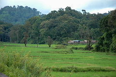
Eastern slope: Rice Paddies (Km 26.4)
After climbing out of the valley spanned by the large bridge the road runs along another ridge before descending steeply into a hidden valley which somewhat surprisingly contains a sizeable area of rice paddies. In the wet season the green paddies, rural shacks and surrounding forest make a very photogenic scene. At Km 26.4 a small bridge crosses a stream. A scan from the bridge is likely to produce Long-tailed Shrike, Pied Bush Chat and Grey Bush Chat.
|
Until recently Jerdon's Bush Chat could be found in rank grass along the stream, but now the grass has been cut back as the number of buffalo increased, such that the chat appears to have deserted the area. A walk around the paddies and stream edge in the dry season, when the paddies lie fallow, can produce Pin-tailed Snipe, Siberian Rubythroat, Bluethroat and the occasional Crested Bunting. This is also one of the few reliable places in northern Thailand to find Oriental Turtle Dove. A small track, about 50 metres before the bridge, on the right, leads across the paddies and into scrub, secondary forest and further paddies. This whole area of paddies stretches along the valley some way, and is rarely explored. |
Eastern slope: Rice Paddies to Camp site (Km 26.4 - 31.0)
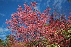
This steep section runs along a ridge with open secondary growth a well as a fair number of cherry trees that bloom extensively in January. At first glance this area does not look very appealing, but time spent here can be well rewarded with possibilities including Grey-headed Parakeet, White-headed Bulbul, Pale Blue Flycatcher, Grey-headed Parrotbill, and surprisingly Himalayan Cutia , which has been seen in the upper section near the camp site.
|
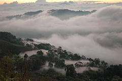
The last stretch before the camp site is a two kilometre steep incline, and a good test for vehicle cooling systems. Occasionally there is a barrier across the road just below the campsite, which is supposed to stop wandering cows and buffalo. The upper part, on the right hand side, just before the camp site, has previously been clear-felled. and offers expansive views across the valley and rice paddies below. On cold, dry season early mornings a sea of fog sometimes fills the valley. This open area has recently been replanted so the open views are likely to disappear over the years. On most evenings large numbers of Cook's Swift pass overhead. |
Scrub around the camp site holds Hill Prinia and White-bellied Redstart, and a check of the cleared areas around the adjacent pond and in tall trees, on the left hand side of the road, might produce Little Bunting, Grey-headed Canary-flycatcher, Grey Treepie and Maroon Oriole.
Eastern slope: Camp site to Upper Army Camp (Km 31.0 - 34.0)
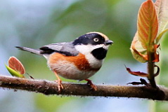
Immediately after the camp site taller evergreen forest starts - initially somewhat patchy and cut-over. However, the steep section immediately after the camp site often has fruiting bushes around which a good number of interesting species can often be found including Silver-eared Laughingthrush, Scarlet-faced Liocichla, Spectacled Barwing, Dark-backed Sibia and Crested Finchbill. This is also the lower limit of Necklaced Woodpecker. Check low vegetation for Little Bunting, White-bellied Redstart and Radde's Warbler. Continuing farther up, the road passes various areas of open and closed evergreen forest and, although some sections are rather steep, anywhere along here is worthy of inspection. Rufous-throated Partridge can often be heard, and other possibilities include Eyebrowed Wren-Babbler, Aberrant Bush Warbler, Large Niltava, Fire-capped Tit, Red-headed Trogon, Himalayan Bluetail, Yunnan Fulvetta and White-necked Laughingthrush to name but a few. In cold winters migrant thrushes could include Eyebrowed Thrush, Chestnut Thrush and Black-breasted Thrush. Just before the upper army camp tall evergreen forest with many epiphytes and lichens start to appear and look good. Around here can be good for Golden Babbler, Necklaced Woodpecker, White-headed Bulbul and Chestnut-headed Tesia.
|
Eastern side: Upper Army Camp to Viewpoint (Km 34.0 - 38.9) In the past couple of years the few personnel at this upper army camp have gotten very accustomed to visiting birders and photographers; so much so that they are often a good source of information on what birds are being seen, and they are well aware of the target species, such as the cutia, that birders are seeking, and of recent sightings. They also feed the birds with rice scraps and fruit, so that several species are confiding and easily photographed behind the camp, including Scarlet-faced Liocichla, Himalayan Bluetail, Dark-backed Sibia, Silver-eared Laughingthrush and often Rufous-gorgeted Flycatcher. Occasionally Rufous-throated Partridge wanders through the area. As these local birds consume a fair amount of food throughout the day it's a welcome gesture to bring a large bunch of bananas to assist the army staff to feed them. Immediately after the army camp the road descends a fairly steep slope and then continues, more or less on the level, for a couple of kilometres. It is well worth walking this section as most of the area's specialities have been found her from time to time, including Black-throated Bushtit, Yellow-browed Tit, Crested Finchbill, Black-eared Shrike-babbler, Chestnut-crowned Warbler, Long-tailed Sibia, Whiskered Yuhina and Necklaced Woodpecker. Forest understorey species include Chestnut-headed Tesia, Slaty-bellied Tesia, Lesser Shortwing, White-tailed Robinnd, very rarely, Spotted Elachura. A good wide track is found on the left at Km 35.8. This passes through primary forest, cut-over and cleared areas and runs for about 1.5 kilometres to a blockage across the track - presumably to stop wandering cows. The trail continues steeply downward. Generally this trail appears quiet but some interesting birds have been found such as White's Thrush, Red-eyed Scimitar Babbler and Grey-headed Parrotbill. It's a good area for Bay Woodpecker and Rusty-naped Pitta occurs. The habitat continues in much the same vein to the San Ju viewpoint at Km 38.9, with any area worthy of a stop and investigation. Great Barbet is often found. After dark Grey Nightjar and Mountain Scops Owl are possible. Eastern slope: San Ju viewpoint to Summit (Km 38.9 - 39.8) Just before the summit area, at Km 38.9, a very large viewpoint, the San Ju viewpoint, is passed, from which Tai Yai (Shan State Army) camps can be seen dotted on the hill tops across the valley. It's seems to be somewhat nebulous where the border actually is in this area. This open slope is badly burnt each dry season, which prevents trees from reestablishing. However it's good for a few species such as Brown-breasted Bulbul and, when the Buddleia bushes are in bloom, good numbers of Mrs. Gould's Sunbird and, rarely, Fire-tailed Sunbird. Other open country birds include Chestnut Bunting, Buff-barred Warbler and Red-eyed Scimitar Babbler. The Thai side is still forested with good views into adjacent tree-tops which are good for Golden-throated Barbet, Black Bulbul, White-headed Bulbul and occasionally Green Cochoa if trees are in fruit. A few hundred metres after the viewpoint the road levels out at its highest elevation around 2,100 metres. This area is often cold and windswept and correspondingly birdless. Given better conditions though a walk in this area and beyond can include some good species such as Hume's Treecreeper, Spot-winged Grosbeak, Green Cochoa, Black-throated Bushtit, Whiskered Yuhina and Scarlet-faced Liocichla. In the past, notable birds have included Dark-breasted Rosefinch, Rusty-naped Pitta and Red-tailed Laughingthrush. Just before the highest point of the road a set of mud steps cut into the hillside is the start of the forest trail to Doi Pha Hom Pok. This trail should not be attempted lightly, as in addition to not knowing the state of the trail, this area has in the past been used as a smuggling route from Burma. It would be very advisable to talk to the locals at the upper army camp before contemplating this. |
Checklist
Checklist of species.
Gallery
Additional images from Doi Lang available in the Thailand Travel gallery.
Sunrise and Sunset
Detailed sunrise and sunset times.