Overview
Mae Taeng Irrigation Project is centred around the water take-up for one of the major canal systems of the area, combined with nearby agricultural development. As with most scrub and farmland areas around the country, the intensification and expansion of agriculture have had a detrimental effect on the wildlife to be found. Nonetheless Mae Teang can still make a rewarding short visit when passing to or from sites farther north. Information on this page verified/accurate as of 16 Dec 2024.
|
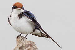
AccessThe turn off to the Irrigation Project lies just to the south of Mae Taeng town, 38 kilometres north of Chiang Mai. From Chiang Mai head north on Highway 107, toward Chiang Dao and Fang, and turn left, 300 metres after the Km 38 marker. This turning is marked by a set of traffic lights, and a large sign, in Thai only, announces the entrance. Access is open and free. From the turnoff it is 6.9 kilometres to a parking area adjacent to the river, where a small park, a few seats and a toilet block can be found. In addition to birding it makes a pleasant picnic area in the cooler months. Accommodation and FacilitiesOnce off Highway 107 no facilities are found. Accommodation can be found in several resorts close to Highway 107 either side of Mae Taeng town, or within Chiang Mai itself. BirdingOver the years a fair number of migrants have turned up, and with the variety of habitats almost anything could be found. It's important to arrive at Mae Taeng early, before the day heats up. Wire-tailed Swallow is usually recorded, and this is one of the most relaible areas in northern Thailand to encounter it. |
The tracks on the eastern side of the river are best accessed from the parking area by walking across the weir. However, this is only possible in the drier months, usually from November to April. Outside this period, if the river level is too high, the fields can be accessed by returning to the staggered junction, 500 metres before the parking area, and taking the paved road across to the temple and then heading north for a couple of kilometres. Access tracks change from time to time so it will be necessary to explore any suitable track heading toward the river. During 2022, much of the immediate area accessible beyond the weir was cleared and converted into a couple of large lakes, most likely for recreational fishing.
|
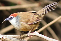
Weir, Canal and River When driving toward the parking area from the main highway keep an eye open for Wire-tailed Swallow feeding along the canal. This species has a strong association with water and birds often follow the canals into urban areas. House Swift nests under small bridges crossing the canal. The river at the parking area should be scanned for waders, with Grey-headed Lapwing, Eastern Little Ringed Plover and Green Sandpiper regular. Swifts often come to the river to drink during the hot season, with Himalayan Swiftlet and Brown-backed Needletail occurring. Cross the weir and explore the rank vegetation of the banks where Chestnut-capped Babbler, Yellow-bellied Prinia and Thick-billed Warbler should be findable. Fields and Tracks Area Once across the weir, a maze of tracks, fields and rank ditches can be explored. Crested Bunting, a decidedly scarce winter visitor in Thailand was formerly found in this area. Baikal Bush Warbler, Lanceolated Warbler and Siberian Rubythroat are fairly common by voice in dense vegetation. Species of scrub and open areas include Indochinese Bush Lark, Red Avadavat and Chestnut-tailed Starling. |
Checklist
Checklist of species.
Gallery
Additional images from Mae Taeng available in the Thailand Travel gallery.
Sunrise and Sunset
Detailed sunrise and sunset times.