Overview
Khun Nan National Park covers an area of 246 square kilometres on the eastern edge of northern Thailand adjacent to the border with Laos. The habitat is mid-elevation and evergreen forests - although access to it is somewhat limited by lack of trails. Only recently have facilities for visitors been established which, combined with its more remote location, mean few visitors. Close to zero, birders have visited. Information on this page verified/accurate as of 11 Nov 202.
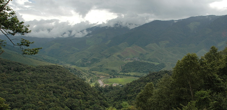
View from viewing platform across to Laos border
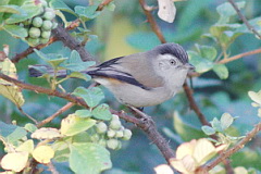
If visiting Doi Phu Kha National Park, Khun Nan can easily be added as a half day trip, and with the accessible HQ area at 900 - 1,000 metres in altitude, the forest is slightly lower and can offer additional species. Two species which appear more common here that at Doi Phu Kha are Indochinese Yuhina and Buff-breasted Babbler.
Access
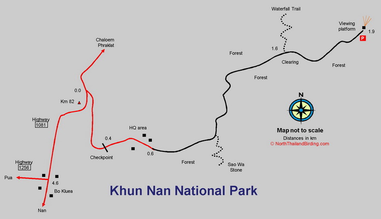
Khun Nan National Park lies a few kilometres north of the small town of Bo Kluea, itself about 60 kilometres northeast of Nan, and directly east of Doi Phu Kha National Park - for which see directions. From Bo Kluea head north, along Highway 1081 toward Chaloem Phraket, for 4.5 kilometres, to the park entrance, signed on the right hand side. Coming directly from Nan, on Highway 1081, is also possible. The park entrance is 300 metres after the Km 82 marker.
Accommodation and Facilities
The park itself has two or three newly constructed bungalows that can be booked in the usual way through the National Parks reservation system. Camping is possible. Currently no restaurant facilities are available. However, as Khun Nan can be visited as a short trip from Doi Phu Kha, it would be easiest to stay at one of the small resorts at Bo Kluea which can be used as a base for both sites.
Birding
This area is not well studied. Other than inside the park, it may be possible to bird along the main Highway 1081, as it's not particularly busy with traffic. Continuing past the park entrance, northward for a couple of kilometres, there's a dirt track eastward into the valley below the viewpoint, where fallow rice paddies in the dry season might hold something interesting. Inside the park the best birding is found along the 1.3 kilometre access track to the viewpoint or the Nature Trail.
Viewpoint Track
Although this rough track is easily drivable in the dry season it's better to park in the HQ area at the end of the paved road and walk.
|
The forest along here is somewhat mixed with both open, and denser patches. Brown-cheeked Fulvetta is common, with other mid elevation species such as Grey-eyed Bulbul, Ashy Bulbul, Blue-winged Minla, White-browed Shrike-babbler, Dark-necked Tailorbird and White-throated Fantail. Buff-breasted Babbler is regular, and Orange-breasted Trogon and Grey Treepie occurs. Careful attention to wintering Phylloscopus warblers could pay dividends. |
|
Viewpoint
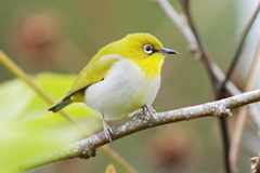
A wooden platform at the end of the track allows excellent views across forested slopes and the valley below, that has a small rice-growing community. Scanning for pigeons and raptors should be worthwhile. Both Indochinese Yuhina and Indian White-eye appear to be regular around the platform.
Nature Trail
In 2018 a signed Nature Trail, starting by the stream at the rear of the campsite, was opened. This offers access to riverine forest and good birding. How long the trail remains walkable, due to any lack of maintenance, remains to be seen. In April 2019 it was possible to follow this trail, four kilometres, to the other side of the park at the Sapan Waterfall. However, in May 2019 large tree falls already made following the trail difficult. Rufous-throated Fulvetta occurs along this trail.
Waterfall Trail and Sao Wa Stone Trail
Two short trails can be found off the main track. Both are sign posted, but lack of visitors and maintenance means both are likely to be overgrown. The Waterfall Trail passes through more open forest. The Sao Wa Stone trail is in evergreen forest.
Checklist
Checklist of species.
Gallery
Additional images from Khun Nan available in the Thailand Travel gallery.
Sunrise and Sunset
Detailed sunrise and sunset times.