Section 1 - Introduction, logistics, itinerary and general information.
Section 2 - Birding sites (part 1).
Section 3 - Birding sites (part 2).
Section 4 - Birding sites (part 3).
Section 5 - Annotated checklist.
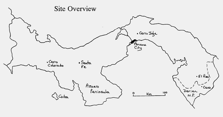
Birding Sites
Included below are details of accommodation, access, habitat and a species list for each site. Species which were personally seen/heard are indicated by the number seen/heard, or with a 'c' which denotes that the bird was common or fairly so. Species listed without a number have been recorded at that site, but by other observers. Bold typeface identifies species of particular note; either rare, endemic, or which might be considered a 'target' bird at that locality.
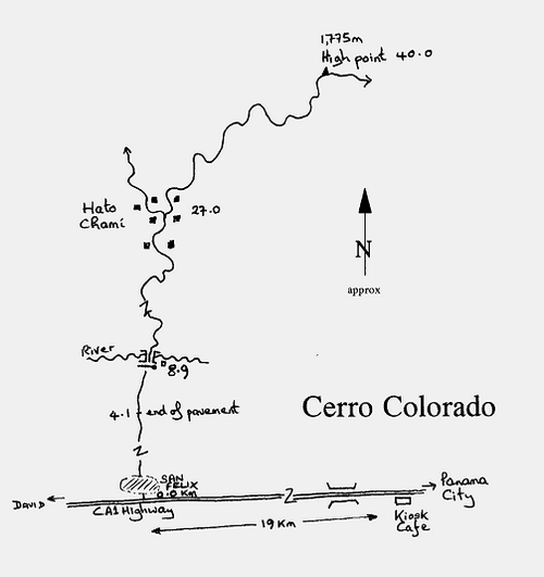
Cerro Colorado
What is left of the accessible forest around Cerro Colorado in eastern Chiriquí is the best place to find the highly sought after, endemic Glow-throated Hummingbird and Yellow-green Brushfinch, both of which are scarce even here. Due to the condition of the road, access is difficult except in the height of the dry season, when a 4x4 is still required. Outside the dry season, rain, heavy trucks and poor maintenance combine to make the road a complete mire of mud. Consequently, few birders have visited this rich area. For those without transport I did see a couple of pick-up trucks transporting passengers between San Felix and Cerro Colorado, although how frequently they plough (literally) this route was not clear.
At San Felix, 117 kilometres west of Santiago, turn right, north, off the main highway and zero the trip meter. (Note that for those on the road early, a small red and white kiosk opening early and selling freshly made empanadas, can be found along the main road 19 kilometres east of San Felix, just before a large iron bridge over the river.) Keep straight ahead through town, continuing on the gravel road to 8.9 kilometres, and a barrier and guard post. Although this is a public road, the mining company, which presumably maintains the road may ask for permission to continue. I had no problem either time I passed, and just waved at the guard. It is probably not a good idea to flash binoculars and tell the guard you are birding, as the miners are suspicious of conservationists, and the like, who may be spying on their activities decimating the habitat. Follow the road to 27.0 kilometres to arrive at the village of Hato Chamí, where the road forks. Keep to the right. From here it is another 13.0 kilometres to the highest point of the road at 1,775 metres. Once past Hato Chamí the birding is good anywhere forest remains. As the Yellow-green Brushfinch is more likely at higher elevations it may be a good idea to start at the top and work down. There is no grocery store, water or accommodation. The nearest accommodation is the Hotel Castillo just west of San Felix on the highway.
|
Not withstanding the possibility of heavy rain, camping along the road above Hato Chamí would be easy. Few cars or people travel this road, and there are several flat areas where one might pitch a tent. Interestingly, once off the main highway, local Indian culture is very strong, with almost all women dressed traditionally. It was the major surprise, and disappointment, to find Scintillant Hummingbird to be common here. According to Ridgely and Gwynne (1989) there is only one record of Scintillant (which occurs in western Chiriquí and Costa Rica) from the nearby Cerro Flores. Our observations of 20+ individuals included three fully plumaged males, and several females studied at length through a scope. Given the low proportion of males it is possible that some earlier sightings of "Glow-throats" may have been female Scintillant. This might have led to the erroneous conception that only Glow-throated Hummingbird occurs in this area. |
Species recorded from Cerro Colorado:
Little Tinamou h |
Scale-crested Pygmy-Tyrant 1 Tropical Kingbird 2 Fork-tailed Flycatcher 1 Great Kiskadee 1 Black-and-yellow Silky Flycatcher 2+ Orange-billed Nightingale-Thrush h Swainson's Thrush 2 Mountain Thrush 2+ Clay-coloured Thrush 4+ House Wren 2+ Blue-and-white Swallow 50+ Golden-winged Warbler 1 Flame-throated Warbler 2 Black-throated Green Warbler 1 Black-and-white Warbler 2 Slate-throated Redstart 1 Collared Redstart 1 Golden-crowned Warbler 3 Yellow-throated Brushfinch 2 Yellow-green Brushfinch 3 Common Chlorospingus 4 Sooty-capped Chlorospingus 10 Western Tanager 1 Blue-grey Tanager 2 Scarlet-thighed Dacnis 2 Blue-black Grassquit c Variable Seedeater c Slaty Flower-piercer 4 Black-thighed Grosbeak 1 Northern Oriole 1 |
Santa Fe
Santa Fe was visited on the strength of its adjacency to Cerro Tute; one of only three areas where the Glow-throated Hummingbird has been recorded this century (Collar et al., 1992). As indicated, this species is evidently rare even here, as three days of searching failed to locate it, including being able to bird right to the summit of Cerro Tute. However, plenty of habitat remains and it would seem likely that further searches should be rewarded. Having no site information, other than an overview in Ridgely and Gwynne (1989), much time was spent exploring tracks and trails in an endeavour to find access to the higher forested ridges.
Santa Fe itself, 56 kilometres north of Santiago, is easily accessible by paved road. Drive west from Panama City along the International CA-1 highway. As you approach Santiago a major fork goes off left into the town proper. Keep right (on the main highway). Immediately after this fork, on the right, you see the Centro Piramidal with a large Texaco station, behind which is the Hotel Piramidal, which at $29/double is a good place to stay. The chinese restaurant next to the Texaco station was excellent and cheap. Several stores/supermarkets can be found in this area, which are the last chance to stock up if going up to Santa Fe. From the Centro Piramidal, the right hand, north, turning to Santa Fe is found at the cross-roads a further 1.1 kilometres westward along the highway. (If you pass under the white foot-bridge over the highway you have gone too far). Zero the trip-meter when turning off the highway, and follow the road north to Santa Fe. At 8.5 kilometres you pass a pig farm, and at the fork at 17.1 kilometres keep left.
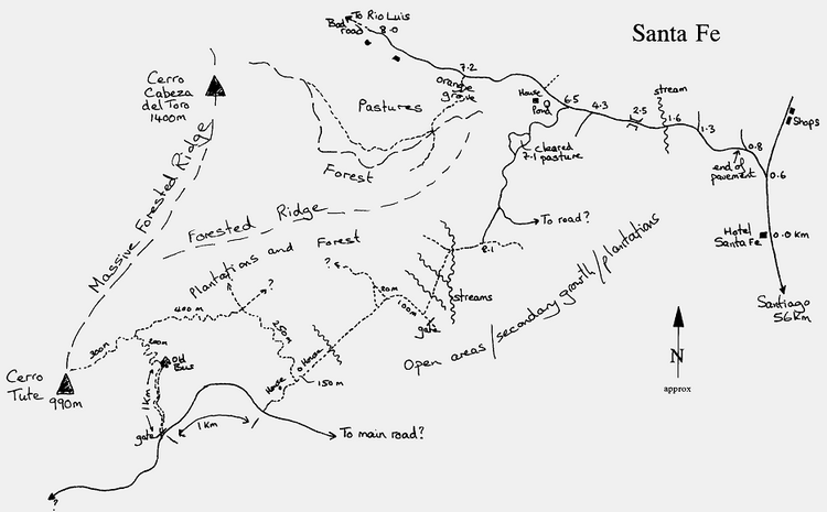
Once at Santa Fe, a 4x4 vehicle is preferable for further exploration, although those prepared to walk extensively can bird many areas near the town. Typically, the habitat around town and along access tracks is mostly cleared plantations, with a few areas of secondary forest. High steep ridges above town are heavily forested, but largely inaccessible. The only accommodation is the Hotel Santa Fe ($13/single), a basic but clean establishment, found on the left just before entering Santa Fe. Evening meals can be provided, and there is a small bar. The stores in town have only very basic foodstuffs.
Cerro Tute, and the forested ridges above Santa Fe dominate the last few kilometres as you approach. Tute is the lower, left hand hill at the western end of the ridge. Access to forest was gained in two main areas; pastures and forest edge 7-8 kilometres west of town along the road to Rio Luis, and a series of tracks and trails 6 kilometres west of town eventually offering access to Cerro Tute. Finding an access trail up Cerro Tute took some time, and is shown in the map. Although every attempt has been made to make this map accurate, the complexity of the trails and possible changes over time may make finding the same route difficult. From the hotel, take the left hand fork 0.6 kilometres after the hotel and follow the map; keep to the main track. After 8.0 kilometres the road was impassable except on foot, but a track at 7.2 kilometres passes up through an orange grove (ask permission to enter) and can be followed for a kilometre or more to forest edge. The trail up-hill through the forest can be found if keeping to the left side of the valley. This 300 metre trail was the only place Spotted Barbtail was seen.
Returning to the main track, a well-marked, stone road (very rough) branches off south at 6.5 kilometres. This track passes through some nice forest edge, and is driveable to a cleared area at 7.1 kilometres, after which it is better to walk. This looks like ideal edge habitat for Glow-throated Hummingbird, though Rufous-tailed Hummingbird is common and aggressive here. To find the path to Cerro Tute continue along this track to about 8.1 kilometres and walk the various trails through plantations and forest edge (distances given on map are estimates). If you get lost, just follow trails running parallel with the ridge and you should arrive on a wide dirt road, which presumably leads back to the main road below. This road climbs steadily through open pasture. After a further kilometre walk right, down a wide driveable track, through a gate, into low forest edge, where you will find an abandoned bus and a small hut where locals process coffee. Just before the bus, on the left a narrow trail passes up through coffee shade-forest and orange groves to eventually arrive at Cerro Tute summit. Once here it is easy to follow other trails, back through the shade forest, toward Santa Fe. Be aware that all these plantations are owned and farmed by the local people. Those that I encountered were quite happy to point me in the direction of Tute and invited me to eat as many oranges as I wished en route. From the 8.1 kilometre point to the top of Tute is about 5 kilometres, and takes about 3-4 hours if birding en route.
Another area investigated was the road to Los Altos, which branches off the main Santiago-Santa Fe road, just below the bridge spanning the river a few kilometres below Santa Fe. On the map, this road looked promising, as a few kilometres beyond Los Altos the road ascends a high ridge. However, the road conditions were appalling - impassable after 7 kilometres. To make matters worse, forest clearance appeared to the wholesale. Excellent forest remains on the hills on the northern side of the road to Rio Luis, though access appears impossible without an expedition. Additionally, if one was lucky enough to find the road to Rio Luis open, it might be well worth exploring. Although the species seen in the three days spent here was not particulary impressive, many interesting species have been recorded, such as White-tipped Sicklebill, Snowcap, and Striped Woodhaunter.
Species recorded from Santa Fe:
Black Vulture c |
Tropical Kingbird c Great Kiskadee 1h Black-chested Jay 4 Clay-coloured Thrush 4 White-throated Thrush 30+ Rufous-breasted Wren 6 Bay Wren 4 House Wren 2 White-breasted Wood-Wren 2 Long-billed Gnatwren 2 Grey-breasted Martin 2 Blue-and-white Swallow 4 Barn Swallow 2 Golden-winged Warbler 1 Tropical Parula 6 Chestnut-sided Warbler 1 Blackburnian Warbler 1 Bay-breasted Warbler 1 Black-and-white Warbler 1 Wilson's Warbler 1 Chestnut-capped Warbler 4 Buff-rumped Warbler 1 Orange-billed Sparrow 2 Black-striped Sparrow 1h Yellow-throated Chlorospingus 3 Rosy Thrush-Tanager 3+ White-lined Tanager 4+ Red-throated Ant Tanager c Hepatic Tanager 3 Summer Tanager 4 Blue-grey Tanager 6 Palm Tanager 4 Thick-billed Euphonia 1 Tawny-capped Euphonia 2 Golden-browed Chlorophonia 2 Silver-throated Tanager 2 Bay-headed Tanager 10+ Blue-black Grassquit 10+ Yellow-faced Grassquit 3 Black-headed Saltator 8 Buff-throated Saltator c Streaked Saltator 2 Chestnut-headed Oropendola 20+ Scarlet-rumped Cacique 2 Giant Cowbird 1 |
Section 1 - Introduction, logistics, itinerary and general information.
Section 3 - Birding sites (part 2).
Section 4 - Birding sites (part 3).
Section 5 - Annotated checklist.